Humberto’s rhythm with Imelda could save Carolinas
The article discusses the potential interaction between two tropical storms, Hurricane Humberto and Tropical Cyclone Nine (soon to be Hurricane Imelda), which could influence their paths and impact on the Carolinas. Hurricane Humberto, a Category 4 storm with winds of 145 mph, is located far northeast of the Northern Leeward Islands and expected to strengthen over the weekend. Tropical Cyclone Nine, near Cuba and the Bahamas, is forecasted to become a tropical storm by Sunday and possibly a hurricane by Monday or Tuesday.
Forecasters suggest that Humberto’s influence might alter Imelda’s trajectory or intensity, potentially preventing major damage to North and South Carolina.The storms could interact in various ways, including the rare Fujiwhara Effect, where two storms rotate around a common center.while South Carolina’s governor has declared a state of emergency, North Carolina’s governor had not done so as of the report. heavy rainfall and flooding remain notable concerns along the southeastern U.S. coast.
Humberto’s rhythm with Imelda could save Carolinas
(The Center Square) – Residents of the Carolinas, seldom fans of hurricanes, much less those reaching Category 5, are hopeful for a rhythm between Humberto and Imelda.
Category 4 Hurricane Humberto, about 365 miles north-northeast of the Northern Leeward Islands at 11 a.m. Saturday is expected to strengthen its 145 mph maximum sustained winds through the weekend. Its pull could be enough to interact with Tropical Cyclone Nine – the possible soon-to-be Hurricane Imelda – in the Atlantic Ocean and thwart major damage in North and South Carolina.
Humberto’s forecasted track by the National Hurricane Center is a swing away from the United States. Sometime Tuesday or Wednesday is the forecast for when the storms will be closest if remaining independent, and each will be due east of the coast between Wilmington in North Carolina and the state border of South Carolina and Georgia.
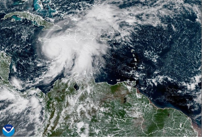
Tropical Cyclone Nine, at 11 a.m. Saturday was 180 miles northwest of the eastern tip of Cuba, about 115 miles south of the central Bahamas. Its maximum sustained winds of 35 mph are expected to increase, making it a tropical storm on or before Sunday as it approaches the American mainland early in the week.
And it is expected to stall. From coastal Georgia through the Mid-Atlantic states, the Hurricane Center says rainfall could cause flash, urban ,and river flooding.
Hurricane status for Imelda, meaning maximum sustained winds of 74-95 mph, is predicted late Monday or early Tuesday.
Forecasters say Humberto could pull Imelda to the east; could pull Imelda apart; could form one even larger storm; or in the rarest of possibilities, could engage in the Fujiwhara Effect swirling around a spot similar to what Philippe and Rina did in 2023.
ONE-YEAR MARK OF STORM THAT COST GEORGIA BILLIONS
Humberto will be the lead on whatever dance transpires.
South Carolina second-term Republican Gov. Henry McMaster declared an emergency Friday; North Carolina first-term Democratic Gov. Josh Stein, as of 11 a.m. Saturday, has not.
" Conservative News Daily does not always share or support the views and opinions expressed here; they are just those of the writer."


